Built by a Missouri deer hunter for Missouri ground
The hunting map that works with zero signal — and tells you which stand to sit.
Download your county once on Wi-Fi and the aerial, property lines and owner names where the county publishes them, and your stands all work in airplane mode. Check tonight’s wind-and-thermal pick before you lose signal and it rides along. Every new install gets the stand picker free for 14 days, no account, no card. Then Pro is $25 a year, flat.
- Works in airplane mode
- Honest county capability labels
- No per-state fees
- Free Missouri rut calendar
- Stand picker free for 14 days
Parcel lines and owner names come from public county GIS, are approximate, and are available in most counties (92 of 115 have lines, 91 have names). Use them to know whose door to knock on for permission.
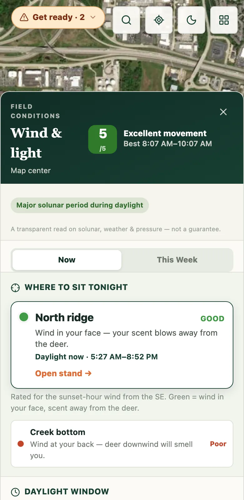
A stand recommendation with the reason, not a mystery score.
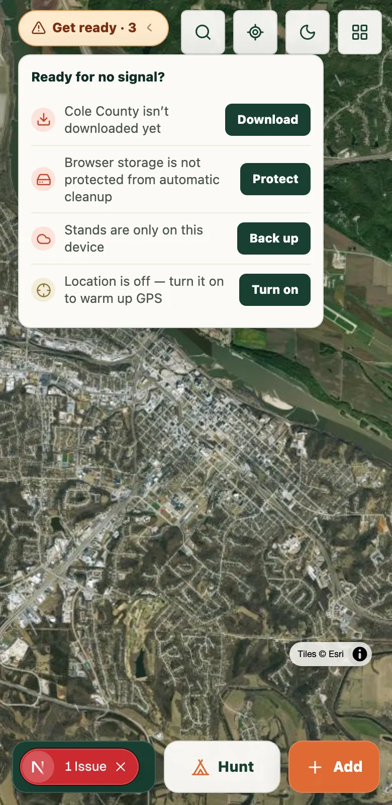
Know what will still work before you lose signal.
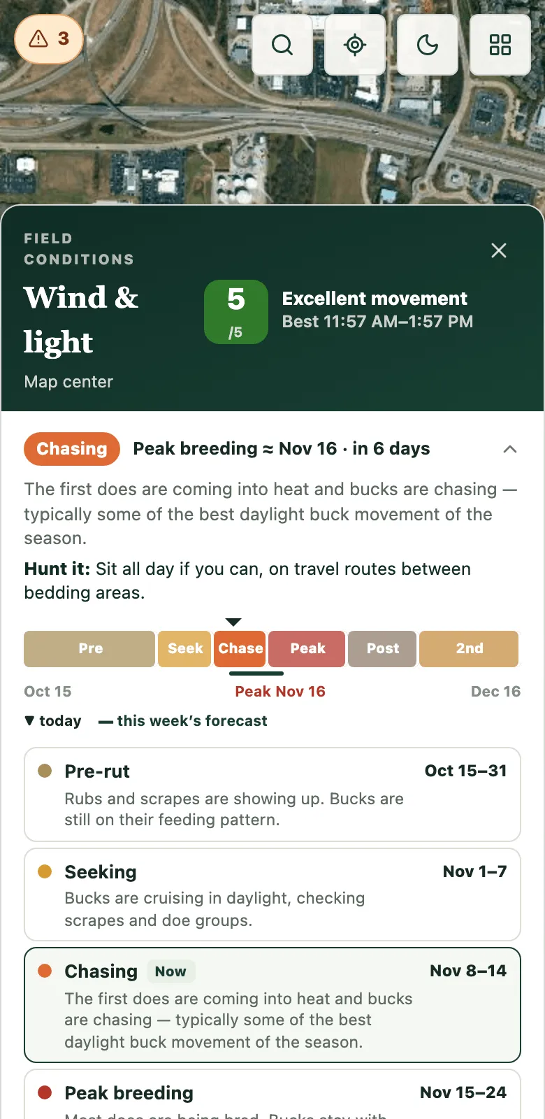
Where the rut stands today — and how to hunt it.
Built for the timber, not the app store.
Fully offline counties
Download your county once on Wi-Fi — USDA aerial imagery, streets, every one of your stands, and parcel data where available keep working deep in the timber.
Your property—even without county parcel data
Tap published parcels for owner details where available. Where they are not, trace your own boundary on the aerial and save it as a property.
A game plan that shows its work
EzMap rates every stand against the wind AND the morning or evening thermals, then tells you why in plain English. No black box — you make the call.
Missouri rut calendar
See where the rut stands today — pre-rut, seeking, chasing, peak breeding — what the bucks are doing, and how to hunt it. Approximate phase windows built around Missouri’s measured breeding peak, and counted in your week’s best days: seeking and chasing days get a scoring boost on top of cold fronts. The calendar is free. With Pro, your logged sits build each stand’s record for each part of the rut — no setup — and after three sits in a stretch, that record helps rank the stand among stands with the same wind rating.
See every Missouri rut date →Gets smarter every sit
Tap “saw deer” or “didn’t” when you climb down, and EzMap stamps the wind, temperature, and pressure on that sit. After a few, it knows which stand produces on a day like today and moves it up your game plan — and during the rut, it keeps each stand’s record for each part of the rut too. The more you hunt your ground, the sharper it reads.
Stand Finder
Reads the terrain inside your property lines for the saddles and benches deer actually use, so you know where to scout before you burn boot leather.
Recovery Mode
Hit one at last light? Red-light blood-trail tracking grids the trail drop by drop and saves it to your map.
Take me there
Tap any stand or camera, or the spot where a buddy last checked in, and an arrow points the way with the yards left as you walk. Free, and your own pins need no signal.
Hunt as a crew
Cloud backup across your devices, shared maps for your buddies, live dots for the whole crew on hunt day plus a who's-hunting-where stand sheet (free for everyone who has your farm code) that badges the stands taken for the hunt that's on now, and a Trophy Room for camp. Camp alerts reach a phone in a pocket with EzMap closed: a buddy's deer-down call, a Trophy Room post, a change on the stand sheet (on iPhone, after adding EzMap to your Home Screen).
“A pin with no reason is a slot machine. The first morning it’s wrong, you’re done trusting it.”
EzMap never hides the reasoning. Every stand pick lays out the wind, the thermals, and the light — plus the rut and your own logged results when they apply — so you can agree, disagree, or overrule it with your gut.
Ready before opening morning.
- 1
Find your ground
Tap a published parcel, or choose Add → Property boundary and trace the corners yourself. Save it as a new property or add it to one you already have.
- 2
Download your county
One download on Wi-Fi puts aerial imagery, streets, and that county's available parcel search on your phone.
- 3
Hunt with zero bars
Airplane mode in the bottoms — the whole map, your stands, and the game plan you pulled before you left signal still work.
Questions hunters ask
Does EzMap work without cell service?
Yes. Download a county once on Wi-Fi and its aerial imagery, streets, available parcel data, and all of your stands work with your phone in airplane mode. Each county card shows whether parcel and owner search are included.
What does EzMap cost?
Free lets you tap published parcels or draw and save your own property boundaries, plus unlimited stands and markups, wind and solunar, the Missouri rut calendar, Recovery Mode, and one offline county. Every new install also gets the stand picker (Game Plan's where-to-sit, the scent-safe walk-in side, and Stand Finder) free for 14 days, no account or card needed. EzMap Pro is $25 per year flat (it renews automatically; cancel anytime) and unlocks every county we publish, the wind-and-thermal stand picker that learns from your logged sits, Stand Finder, the scent-safe walk-in side for every stand, cloud backup, and sharing your farm with your crew. Crew Mode itself is free: anyone who has loaded your farm code sees live dots for everyone out that morning. No per-state fees, no tiers.
Which states does EzMap cover?
Missouri today — offline aerial and streets in all 115 counties, with property boundaries you can draw and save anywhere. Published parcel lines and owner search depend on what each county provides and continue to expand. The live coverage page shows exactly what is included.
Can I see who owns a property?
Yes — in counties with owner data (most parcel counties; each county card shows exactly what it includes, since a few counties publish lines without names). Tap a parcel and see the owner of record, the address, and the acreage — online or offline once your county is downloaded.
Is EzMap an onX or HuntStand alternative?
For Missouri hunters, yes. EzMap covers the core jobs — offline maps, published parcels where available, property boundaries you draw, stand planning, a rut calendar, and tracking — at a flat $25 a year instead of per-state subscription pricing, and it explains its stand picks instead of just dropping a pin.
Does EzMap learn from my hunts?
Yes — and it's what sets EzMap apart. Log each sit with one tap, saw deer or didn't, and EzMap records the wind, temperature, and pressure at the time. Once a stand has a few sits behind it, EzMap weighs your real results on days like today and moves your best-producing stands up the game plan. During the rut it also keeps each stand’s record for each part of the rut; after three sits in a stretch, that record helps rank the stand among stands with the same wind rating. It's your ground and your data — the app just keeps score and does the math. Logging is free; the stand picker that uses it is part of EzMap Pro.
When is the rut in Missouri?
Peak breeding in Missouri is mid-November — about Nov 16 in state fetal-study data — and day length, not the moon, sets it, so the peak stays close to mid-November each year. The phases around it are approximate: bucks typically seek around Nov 1–7 and chase around Nov 8–14, and a smaller second rut follows in early December when doe fawns come into heat. EzMap’s free rut calendar shows today’s phase, what the deer are doing, and how to hunt it, and it counts the rut in your week’s best days. With EzMap Pro, the sits you log build each stand’s record for each part of the rut; after three sits in a stretch, that record helps rank stands with the same wind rating — the wind still comes first.
Do I need the App Store or Play Store?
No. EzMap installs straight from your browser to your home screen on both iPhone and Android — open ezmap.app, choose Install (or Add to Home Screen), and it runs full-screen like any app. Step by step for your phone: ezmap.app/install
Where does the map data come from?
Aerial imagery is USDA NAIP (public domain), published parcel lines come from county assessor data, and the base map is OpenStreetMap. Boundaries you draw come from your own map taps. Neither published nor drawn lines are a survey. Weather and wind come from Open-Meteo.